Indian Geography: IAS General Studies Prelims cum mains
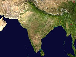
 The geography of India describes the geographic features of India, a country in South Asia. India lies largely on the Indian Plate, the northern portion of the Indo-Australian Plate, whose continental crust forms the Indian subcontinent. The country is situated north of the equator between 8°4' and 37°6' north latitude and 68°7' and 97°25' east longitude.[2] It is the seventh-largest country in the world, with a total area of 3,166,414 square kilometres (1,222,559 sq mi).[3] India measures 3,214 km (1,997 mi) from north to south and 2,933 km (1,822 mi) from east to west. It has a land frontier of 15,200 km (9,445 mi) and a coastline of 7,517 km (4,671 mi).[4]
On the south, India projects into and is bounded by the Indian Ocean – in particular, by the Arabian Sea on the southwest, the Laccadive Sea to the south, and the Bay of Bengal on the southeast. The Palk Strait and Gulf of Mannar separate India from Sri Lanka to its immediate southeast, and theMaldives are some 400 kilometres (250 mi) to the southwest. India's Andaman and Nicobar Islands, some 1,200 kilometres (750 mi) southeast of the mainland, share maritime borders with Burma, Thailand and Indonesia.Kanyakumari at 8°4′41″N and 77°32′28″E is the southernmost tip of the Indian mainland, while the southernmost point in India is Indira Point on Great Nicobar Island.[4] India's territorial waters extend into the sea to a distance of 12 nautical miles (13.8 mi; 22.2 km) from the coast baseline.[5]
The northern frontiers of India are defined largely by the Himalayan mountain range, where the country borders China, Bhutan, and Nepal. Its western border with Pakistan lies in the Punjab Plain and the Thar Desert. In the far northeast, the Chin Hills and Kachin Hills, deeply forested mountainous regions, separate India from Burma. On the east, its border with Bangladeshis largely defined by the Khasi Hills and Mizo Hills, and the watershed region of the Indo-Gangetic Plain.[clarification needed]
The Ganges is the longest river originating in India. The Ganges–Brahmaputra system occupies most of northern, central, and eastern India, while the Deccan Plateau occupies most of southern India.Kangchenjunga, on the border between Nepal and the Indian state of Sikkim, is the highest point in India at 8,598 m (28,209 ft) and the world's 3rd highest peak. Climate across India ranges from equatorial in the far south, to alpineand tundra in the upper reaches of the Himalayas.
The geography of India describes the geographic features of India, a country in South Asia. India lies largely on the Indian Plate, the northern portion of the Indo-Australian Plate, whose continental crust forms the Indian subcontinent. The country is situated north of the equator between 8°4' and 37°6' north latitude and 68°7' and 97°25' east longitude.[2] It is the seventh-largest country in the world, with a total area of 3,166,414 square kilometres (1,222,559 sq mi).[3] India measures 3,214 km (1,997 mi) from north to south and 2,933 km (1,822 mi) from east to west. It has a land frontier of 15,200 km (9,445 mi) and a coastline of 7,517 km (4,671 mi).[4]
On the south, India projects into and is bounded by the Indian Ocean – in particular, by the Arabian Sea on the southwest, the Laccadive Sea to the south, and the Bay of Bengal on the southeast. The Palk Strait and Gulf of Mannar separate India from Sri Lanka to its immediate southeast, and theMaldives are some 400 kilometres (250 mi) to the southwest. India's Andaman and Nicobar Islands, some 1,200 kilometres (750 mi) southeast of the mainland, share maritime borders with Burma, Thailand and Indonesia.Kanyakumari at 8°4′41″N and 77°32′28″E is the southernmost tip of the Indian mainland, while the southernmost point in India is Indira Point on Great Nicobar Island.[4] India's territorial waters extend into the sea to a distance of 12 nautical miles (13.8 mi; 22.2 km) from the coast baseline.[5]
The northern frontiers of India are defined largely by the Himalayan mountain range, where the country borders China, Bhutan, and Nepal. Its western border with Pakistan lies in the Punjab Plain and the Thar Desert. In the far northeast, the Chin Hills and Kachin Hills, deeply forested mountainous regions, separate India from Burma. On the east, its border with Bangladeshis largely defined by the Khasi Hills and Mizo Hills, and the watershed region of the Indo-Gangetic Plain.[clarification needed]
The Ganges is the longest river originating in India. The Ganges–Brahmaputra system occupies most of northern, central, and eastern India, while the Deccan Plateau occupies most of southern India.Kangchenjunga, on the border between Nepal and the Indian state of Sikkim, is the highest point in India at 8,598 m (28,209 ft) and the world's 3rd highest peak. Climate across India ranges from equatorial in the far south, to alpineand tundra in the upper reaches of the Himalayas.
Physiographic regions
India can be divided into five physiographic regions. They are
- The Northern Mountains
- Indo Gangetic Plains
- The Peninsular Plateau
- Thar Desert
- The Coastal Plains
The Northern Mountains[edit]
A great arc of mountains, consisting of the Himalayas, Hindu Kush, and Patkairanges define the northern Indian subcontinent. These were formed by the ongoing tectonic collision of the Indian and Eurasian plates. The mountains in these ranges include some of the world's tallest mountains which act as a natural barrier to cold polar winds. They also facilitate the monsoon winds which in turn influence the climate in India. Rivers originating in these mountains, flow through the fertile Indo–Gangetic plains. These mountains are recognised by biogeographers as the boundary between two of the Earth's great ecozones: the temperate Palearctic that covers most of Eurasia and the tropical and subtropical Indomalaya ecozone which includes the Indian subcontinent, Southeast Asia and Indonesia.
India has eight major mountain ranges having peaks of over 1,000 m (3,300 ft)
- The Himalayan range is considered as the world's highest mountain range, with its tallest peak Mt. Everest (8,854 metres (29,049 ft)) on the Nepal–China border.[15] They form India's northeastern border, separating it from northeastern Asia. They are one of the world's youngest mountain ranges and extend almost uninterrupted for 2,500 km (1,600 mi), covering an area of 500,000 km2(190,000 sq mi).[15] The Himalayas extend from Jammu and Kashmir in the north to Arunachal Pradesh in the east. These states along with Himachal Pradesh, Uttarakhand, and Sikkim lie mostly in the Himalayan region. Numerous Himalayan peaks rise over 7,000 m (23,000 ft) and the snow line ranges between 6,000 m (20,000 ft) in Sikkim to around 3,000 m (9,800 ft) in Kashmir. Kanchenjunga—on the Sikkim–Nepal border—is the highest point in the area administered by India. Most peaks in the Himalayas remain snowbound throughout the year. The Himalayas act as a barrier to the frigid katabatic winds flowing down from Central Asia. Thus, North India is kept warm or only mildly cooled during winter; in summer, the same phenomenon makes India relatively hot.
- The Karakoram is situated in the disputed state of Jammu and Kashmir. It has more than sixty peaks above 7,000 m (23,000 ft), including K2, the second highest peak in the world 8,611 m (28,251 ft). K2 is just 237 m (778 ft) smaller than the 8,848 m (29,029 ft) Mount Everest. The range is about 500 km (310 mi) in length and the most heavily glaciated part of the world outside of the polar regions. The Siachen Glacier at 76 km (47 mi) and the Biafo Glacier at 67 km (42 mi) rank as the world's second and third-longest glaciers outside the polar regions.[16] Just to the west of the northwest end of the Karakoram, lies the Hindu Raj range, beyond which is the Hindu Kush range. The southern boundary of the Karakoram is formed by the Gilgit, Indus and Shyok rivers, which separate the range from the northwestern end of the Himalayas.
- The Patkai, or Purvanchal, are situated near India's eastern border with Burma. They were created by the same tectonic processes which led to the formation of the Himalayas. The physical features of the Patkai mountains are conical peaks, steep slopes and deep valleys. The Patkai ranges are not as rugged or tall as the Himalayas. There are three hill ranges that come under the Patkai: the Patkai–Bum, the Garo–Khasi–Jaintia and the Lushai hills. The Garo–Khasi range lies in Meghalaya. Mawsynram, a village near Cherrapunji lying on the windward side of these hills, has the distinction of being the wettest place in the world, receiving the highest annual rainfall.[17]
- The Vindhya range runs across most of central India, extending 1,050 km (650 mi).[15] The average elevation of these hills is from 300 to 600 m (980 to 1,970 ft) and rarely goes above 700 metres (2,300 ft).[15] They are believed to have been formed by the wastes created by the weathering of the ancient Aravali mountains.[18] Geographically, it separates northern India from southern India. The western end of the range lies in eastern Gujarat, near its border with Madhya Pradesh, and runs east and north, almost meeting the Ganges at Mirzapur.
- The Satpura Range begins in eastern Gujarat near the Arabian Sea coast and runs east across Maharashtra, Madhya Pradesh and Chhattisgarh. It extends 900 km (560 mi) with many peaks rising above 1,000 m (3,300 ft).[15] It is triangular in shape, with its apex at Ratnapuri and the two sides being parallel to the Tapti and Narmada rivers.[19] It runs parallel to the Vindhya Range, which lies to the north, and these two east-west ranges divide the Indo–Gangetic plain from the Deccan Plateau located north of River Narmada.
- The Aravali Range is the oldest mountain range in India, running across Rajasthan from northeast to southwest direction, extending approximately 800 km (500 mi).[20]The northern end of the range continues as isolated hills and rocky ridges into Haryana, ending near Delhi. The highest peak in this range is Guru Shikhar at Mount Abu, rising to 1,722 m (5,650 ft), lying near the border with Gujarat.[21] The Aravali Range is the eroded stub of an ancient fold mountain system.[22] The range rose in aPrecambrian event called the Aravali–Delhi orogen. The range joins two of the ancient segments that make up the Indiancraton, the Marwar segment to the northwest of the range, and the Bundelkhand segment to the southeast.
- The Western Ghats or Sahyadri mountains run along the western edge of India's Deccan Plateau and separate it from a narrow coastal plain along the Arabian Sea. The range runs approximately 1,600 km (990 mi)[19] from south of the Tapti River near the Gujarat–Maharashtra border and across Maharashtra, Goa, Karnataka, Kerala and Tamil Nadu to the southern tip of the Deccan peninsula. The average elevation is around 1,000 m (3,300 ft).[19] Anai Mudi in the Anaimalai Hills 2,695 m (8,842 ft) in Kerala is the highest peak in the Western Ghats.[23]
- The Eastern Ghats are a discontinuous range of mountains, which have been eroded and vivisected by the four major rivers of southern India, the Godavari, Mahanadi, Krishna, and Kaveri.[24] These mountains extend from West Bengal to Orissa, Andhra Pradesh and Tamil Nadu, along the coast and parallel to the Bay of Bengal. Though not as tall as the Western Ghats, some of its peaks are over 1,000 m (3,300 ft) in height.[19] The Nilgiri hills in Tamil Nadu lies at the junction of the Eastern and Western Ghats. Arma Konda (1,680 m (5,510 ft)) in Andhra Pradesh is the tallest peak in Eastern Ghats.[25]


Indo-Gangetic plain
The Indo-Gangetic plains, also known as the Great Plains are large alluvial plains dominated by three main rivers, the Indus,Ganges, and Brahmaputra. They run parallel to the Himalayas, from Jammu and Kashmir in the west to Assam in the east, and drain most of northern and eastern India. The plains encompass an area of 700,000 km2 (270,000 sq mi). The major rivers in this region are the Ganges, Indus, and Brahmaputra along with their main tributaries–Yamuna, Chambal, Gomti,Ghaghara, Kosi, Sutlej, Ravi, Beas, Chenab, and Tista—as well as the rivers of the Ganges Delta, such as the Meghna.

The great plains are sometimes classified into four divisions:
- The Bhabar belt is adjacent to the foothills of the Himalayas and consists of boulders and pebbles which have been carried down by streams. As the porosityof this belt is very high, the streams flow underground. The Bhabar is generally narrow with its width varying between 6 to 15 km (3.7 to 9.3 mi).
- The Terai belt lies south of the adjacent Bhabar region and is composed of newer alluvium. The underground streams reappear in this region. The region is excessively moist and thickly forested. It also receives heavy rainfall throughout the year and is populated with a variety of wildlife.
- The Bangar belt consists of older alluvium and forms the alluvial terrace of the flood plains. In the Gangetic plains, it has a low upland covered by laterite deposits.
- The Khadar belt lies in lowland areas after the Bangar belt. It is made up of fresh newer alluvium which is deposited by the rivers flowing down the plain.
The Indo-Gangetic belt is the world's most extensive expanse of uninterrupted alluvium formed by the deposition of silt by the numerous rivers. The plains are flat making it conducive for irrigation through canals. The area is also rich in ground water sources.
The plains are one of the world's most intensely farmed areas. The main crops grown are rice and wheat, which are grown inrotation. Other important crops grown in the region include maize, sugarcane and cotton. The Indo-Gangetic plains rank among the world's most densely populated areas.[citation needed]
Thar Desert

Main article: Thar Desert
The Thar Desert (also known as the deserts) is by some calculations the world's seventh largest desert,[26] by others the tenth.[27] It forms a significant portion of western India and covers an area of 200,000 to 238,700 km2 (77,200 to 92,200 sq mi).[26][28] The desert continues into Pakistan as the Cholistan Desert. Most of the Thar Desert is situated in Rajasthan, covering 61% of its geographic area.
About 10 percent of this region comprises sand dunes, and the remaining 90 percent consist of craggy rock forms, compacted salt-lake bottoms, and interdunal and fixed dune areas. Annual temperatures can range from 0 °C (32 °F) in the winter to over 50 °C (122 °F) during the summer. Most of the rainfall received in this region is associated with the short July–September southwest monsoon that brings 100 to 500 mm (3.9 to 19.7 in) of precipitation. Water is scarce and occurs at great depths, ranging from 30 to 120 metres (98 to 394 ft) below the ground level.[29] Rainfall is precarious and erratic, ranging from below 120 mm (4.7 in) in the extreme west to 375 mm (14.8 in) eastward.The only river in this region is Luni. The soils of the arid region are generally sandy to sandy-loam in texture. The consistency and depth vary as per the topographical features. The low-lying loams are heavier and may have a hard pan of clay, calcium carbonate or gypsum.
Highlands
The Central Highlands consists of three main plateaus — the Malwa Plateau in the west, the Deccan Plateau in the south (covering most of the Indian peninsula) and the Chota Nagpur Plateau in the east.

The Malwa Plateau is spread across Rajasthan, Madhya Pradesh and Gujarat. The average elevation of the Malwa plateau is 500 metres, and the landscape generally slopes towards the north. Most of the region is drained by the Chambal River and its tributaries; the western part is drained by the upper reaches of the Mahi River.

The Deccan Plateau is a large triangular plateau, bounded by the Vindhyas to the north and flanked by the Eastern and Western Ghats. The Deccan covers a total area of 1.9 million km² (735,000 mile²). It is mostly flat, with elevations ranging from 300 to 600 m (980 to 1,970 ft). The average elevation of the plateau is 2,000 feet (610 m) above sea level. The surface slopes from 3,000 feet (910 m) in the west to 1,500 feet (460 m) in the east.[30] It slopes gently from west to east and gives rise to several peninsular rivers such as theGodavari, the Krishna, the Kaveri and the Mahanadi which drain into the Bay of Bengal. This region is mostly semi-arid as it lies on the leeward side of both Ghats. Much of the Deccan is covered by thorn scrub forest scattered with small regions of deciduous broadleaf forest. Climate in the Deccan ranges from hot summers to mild winters.
The Chota Nagpur Plateau is situated in eastern India, covering much of Jharkhand and adjacent parts of Orissa, Bihar and Chhattisgarh. Its total area is approximately 65,000 km2 (25,000 sq mi) and is made up of three smaller plateaus — the Ranchi, Hazaribagh, and Kodarma plateaus. The Ranchi plateau is the largest, with an average elevation of 700 m (2,300 ft). Much of the plateau is forested, covered by the Chota Nagpur dry deciduous forests. Vast reserves of metal ores and coal have been found in the Chota Nagpur plateau. The Kathiawar peninsula in western Gujarat is bounded by the Gulf of Kutch and the Gulf of Khambat. The natural vegetation in most of the peninsula is xeric scrub, part of the Northwestern thorn scrub forests ecoregion.
In western India, the Kutch region in Gujarat and Koyna in Maharashtra are classified as a Zone IV region (high risk) for earthquakes. The Kutch city of Bhuj was the epicentre of the 2001 Gujarat earthquake, which claimed the lives of more than 1,337 people and injured 166,836 while destroying or damaging near a million homes.[31] The 1993 Latur earthquake in Maharashtra killed 7,928 people and injured 30,000.[32] Other areas have a moderate to low risk of an earthquake occurring.[33]
Coasts

_Beach_View_from_Tenneti_Park_07.JPG)
The Eastern Coastal Plain is a wide stretch of land lying between the Eastern Ghats and the Bay of Bengal. It stretches from Tamil Nadu in the south to West Bengal in the east. The Mahanadi, Godavari, Kaveri, andKrishna rivers drain these plains. The temperature in the coastal regions often exceeds 30 °C (86 °F), and is coupled with high levels of humidity. The region receives both the northeast monsoon and southwest monsoon rains. The southwest monsoon splits into two branches, the Bay of Bengal branch and the Arabian Sea branch. The Bay of Bengal branch moves northwards crossing northeast India in early June. The Arabian Sea branch moves northwards and discharges much of its rain on the windward side of Western Ghats. Annual rainfall in this region averages between 1,000 and 3,000 mm (39 and 118 in). The width of the plains varies between 100 and 130 km (62 and 81 mi).[34] The plains are divided into six regions—the Mahanadi delta, the southern Andhra Pradesh plain, the Krishna-Godavari deltas, the Kanyakumari coast, the Coromandel Coast, and sandy coastal.[citation needed]
The Western Coastal Plain is a narrow strip of land sandwiched between the Western Ghats and the Arabian Sea, ranging from 50 to 100 km (31 to 62 mi) in width. It extends from Gujarat in the north and extends through Maharashtra, Goa, Karnataka, and Kerala. Numerous rivers and backwaters inundate the region. Mostly originating in the Western Ghats, the rivers are fast-flowing, usually perennial, and empty into estuaries. Major rivers flowing into the sea are the Tapi, Narmada,Mandovi and Zuari. Vegetation is mostly deciduous, but the Malabar Coast moist forests constitute a unique ecoregion. The Western Coastal Plain can be divided into two parts, the Konkan and the Malabar Coast.
Islands

See also: List of islands of India
The Lakshadweep and the Andaman and Nicobar Islands are India's two major island formations and are classified as union territories. The Lakshadweep Islands lie 200 to 300 km (120 to 190 mi) off the coast of Kerala in the Arabian sea with an area of 32 km2 (12 sq mi). They consist of twelve atolls, three reefs, and five submerged banks, with a total of about 35 islands and islets.
The Andaman and Nicobar Islands are located between 6° and 14° north latitude and 92° and 94° east longitude.[35] They consist of 572 isles, lying in the Bay of Bengal near the Burmese coast. They are located 1,255 km (780 mi) from Kolkata(Calcutta) and 193 km (120 mi) from Cape Negrais in Burma.[35] The territory consists of two island groups, the Andaman Islands and the Nicobar Islands. The Andaman Islands consists of 204 small islands across a total length of 352 km (219 mi). India's only active volcano, Barren Island is situated here. It last erupted in May 2005. The Narcondum is a dormant volcanoand there is a mud volcano at Baratang. Indira Point, India's southernmost land point, is situated in the Nicobar islands at 6°45’10″N and 93°49’36″E, and lies just 189 km (117 mi) from the Indonesian island of Sumatra, to the southeast. The highest point is Mount Thullier at 642 m (2,106 ft).
Other significant islands in India include Diu daman, a former Portuguese enclave; Majuli, a river island of the Brahmaputra;Elephanta in Bombay Harbour; and Sriharikota, a barrier island in Andhra Pradesh. Salsette Island is India's most populous island on which the city of Mumbai (Bombay) is located. Forty-two islands in the Gulf of Kutch constitute the Marine National Park.